Help Count Bicyclists!
We’re going to continue the bicycle theme this morning …
The Cascade Bicycle Club is working with the Washington State Department of Transportation to track growth in bicycling and walking. They are increasing their data collection in Tacoma this year and could use your help. Are you available for a 2-hour shift on September 29, 30, or October 1 from 7 to 9 am or 4 to 6 pm. The data collected will be used to advocate for better sidewalks, bike lanes and other facilities.
Interested? It’s easy! Just e-mail <txp:dtj_obfuscated_email email="organizer@cascadebicycleclub.org" />g and they will set you up with instructions and let you know which intersections need volunteers.
Thank you for your help.
Filed under: Get-Involved, General
6 comments
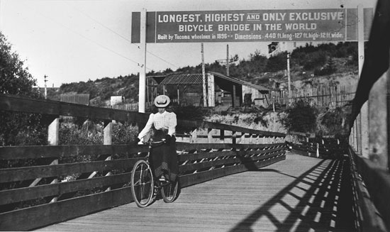
N Narndt September 28, 2009
Again a home run with a Tacoma bicycle image. Where was this bridge??
L Liz Kaster September 28, 2009
Here is the citacion from the Tacoma Public Library:
Date: ca. 1900
Description: Around 1900, a young woman was photographed riding her bicycle across Tacoma’s bicycle bridge. The bridge was constructed in 1896 near Holy Rosary, connecting Delin Street with the path leading to the Hood Street reservoir. For more than 25 years, it was the “longest, highest and only exclusive” bicycle bridge in the world. The narrow wooden bridge was perched on steel poles high above the gulch and provided a way for bicyclists to cross the ravine. The bridge measured in at 440 feet long, 127 feet high and 12 feet wide and was build with funds accrued from the sale of bicycle licenses. (TNT 9/5/1922- in clipping file) TPL-4459
Tacoma Public Library, Richards Studio Collection G15.1-006
R Rob September 28, 2009
Thanks for the question and answer above. I was wondering the same thing about that historic image.
Meanwhile, I wonder about doing a count of cyclists and walkers this Tuesday, when we are predicted to have rain, wind and possible thunderstorms. It sounds like perfect weather to ensure that only the hardiest of walkers and cyclists will be counted…
N Narndt September 28, 2009
Thanks Liz! How cool! I ride my bike up Delin from Pacific every morning. Who would have known? I’ll have to try to piece together where the bridge once stood.
@Rob There’s a space on the count form to describe weather, so hopefully they’ll take that into consideration.
R RGardner September 29, 2009
I got the email from Cascade too – and I really can’t understand the reasoning other than a McNamera-esqe desire for metrics. Let us count the few areas where folks can ride?
The Yakima and Denlin Bridges have restored my ability to get downtown from the largest population area of Tacoma (South End). I still can’t go east-west. But now there is the useless Yakima on-street bike markings, when Park Ave a block away is much better/safer without markings.
This from someone that rode cross-country 7 years ago (TransAm) and I fear my own city when cycling.
Great picture and history.
N Narndt September 29, 2009
@RGardner,
For three years I’ve commuted every day, year-round, south on Yakima from downtown Tacoma to Spanaway every morning and the opposite on Park in the evening. That’s thousands of miles on those roads alone. I’ve always felt safe on Yakima and I feel even better with the bikes lanes. I like Yakima in the morning because I feel drivers are a bit more aware on main streets after they’ve gotten their cell phone and coffee situation settled just after leaving their houses.
Tacoma is a great place for bikes and it’s getting better. Your comment that the bike “markings” on Yakima are “useless” is incorrect. For someone who actually uses them every day, they work great. Why can’t you go east-west? From where to where? There’s plenty of room for bikes already on most Tacoma streets, with or without bike lanes.
Do you bike commute or just cycle for recreation? Because riding cross-country, albeit an accomplishment, really isn’t relevant in the discussion of bike usage in Tacoma.