How Will the Prairie Line Trail Cross 21st Street?
Here’s something we thought a few of you might find interesting, both because it has to do with the Prairie Line Trail, and because we get to use the phrase “road diet,” which makes any story better.
As conversations continue over the design of the Hood Corridor Prairie Line Trail through the UW Tacoma campus, the City and the University are looking at the next little piece of the trail: the crossing at 21st Street.
The Prairie Line Trail intersects 21st Street mid-block, mid-slope, just downhill from the existing Jefferson Street traffic signal on the busy 21st Street approach to Pacific Avenue and I-705 freeway entrances. A location like that presents a challenge in creating a crossing that is safe and functional for both drivers and bicyclists/pedestrians. The City has been working with a consultant to come up with options, and on May 14, they presented their top three to the Chamber.
Click to enlarge images.
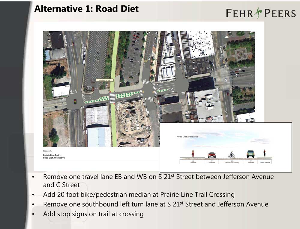
Alternative 1: Road Diet – This option would shrink 21st Street, removing one lane of travel in the block between Jefferson and C Street. A bike/pedestrian crossing would be added to allow the Prairie Line Trail to continue straight across 21st without diversion.

Alternative 2: Partial Road Diet / C Street Signal – This option would divert the Prairie Line Trail to a new signal at C Street. Prairie Line Trail traffic would be diverted along newly widened sidewalks/paths on either side of 21st Street. 21st would be slightly narrowed in this section.
Alternative 3: C Street Signal – This option would retain all flow of vehicle traffic on 21st Street. As with alternative 2, Prairie Line Trail traffic would be redirected along widened sidewalks/paths, and a new signal would be installed at C Street.
Solutions considered, but not moved forward on included a tunnel option, elevated structure, trail relocation to the existing Jefferson Street signal, and installing a signal at the Prairie Line Trail crossing.
It’s a tricky location, with a lot of considerations – flow of traffic (both vehicle and bike/pedestrian), safety, cost… We haven’t heard a lot about this so far, but we’re guessing there will be more conversations coming.
Download the presentation (pdf)
Spotted via tacomadowntown.blogspot.com.
Filed under: Downtown Tacoma, Transportation, Biking, Neighborhoods, UWT, City Projects, South Downtown Planning, Colleges & Universities, Prairie Line Trail
5 comments
J Jake May 24, 2012
Getting rid of lanes is not a good idea in that location. It is already congested. Plus there will be an eventual shift of the arterial from 19th to 21st all the way up to Tacoma Ave.
R RR Anderson May 24, 2012
slip ramps!
R RR Anderson May 24, 2012
no, Tunnel ? Isn’t seattle almost done with the boring machine?
A AreteTacoma May 25, 2012
Why would they need to narrow the westbound direction? They can build the widened trail section by aquiring land to the north, from the state owned parking lot. It is too bad there will not be a grade separated path, but there is no elegant, safe, or cost effective way to do so.
J Jenny Jenkins May 29, 2012
That’s such a nasty street to try to cross on foot/bike the way it is right now – I think any change would be an improvement. Too bad the pedestrian/bike bridge is so expensive – that seems like the safest alternative.