Port Public Access Plan Moves Forward
Tacoma’s Shoreline Master Program requires public agencies, including the Port of Tacoma, to provide public access to the waterfront when projects require a City shoreline permit. These requirements were added in the last update of the SMP, and the Port of Tacoma has been working to create a public access plan.
Definition of public access: Public access is defined as the ability of the public to reach, touch and enjoy the water’s edge, to travel on the waters of the state, and to view the water and the shoreline from adjacent locations [Washington Administrative Code 173-26-221 (4)(a)].
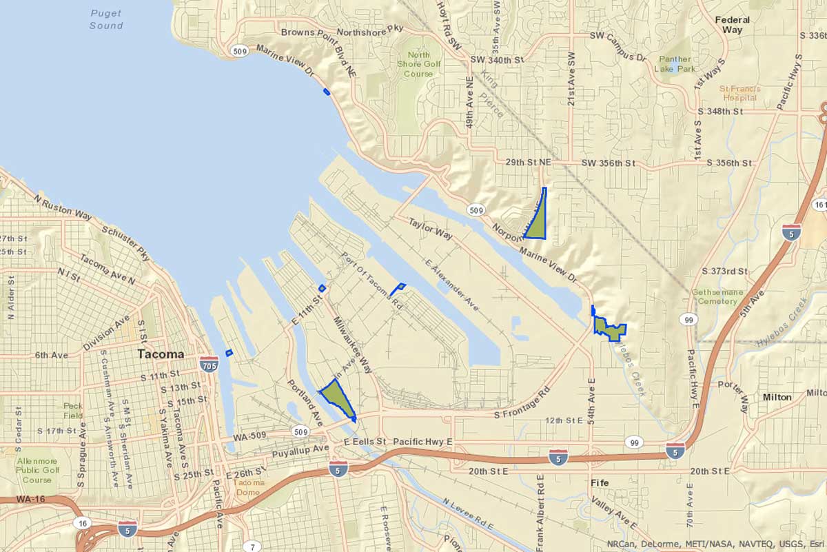
In the past Tacoma allowed public access requirements to be waived for projects with safety or security concerns, but under the new program, the City requires that projects that cannot accomodate public access on site provide it elsewhere. A handful of public access points within the Port have been identified to fulfill requirements for public access as defined by the state (identified on map above):
- Dick Gilmur Shoreline Restoration and Kayak Launch Launch your kayak and view wildlife from this habitat site along Marine View Drive.
- Gog-le-hi-te Wetlands A public overlook provides views of wetland habitat along the Puyallup River.
- Julia’s Gulch About 70 acres of open space serve as a natural buffer between the Port and residential neighborhoods.
- Observation Tower The four-story tower provides panoramic views of the Port operations on the Sitcum Waterway.
- Place of Circling Waters A public overlook provides views of 30 acres of restored habitat at the mouth of Hylebos Creek.
- Rhone Polenc A public overlook provides views of salt marsh and mudflat habitat ideal for young salmon.
One example of the Port’s efforts at creating public access was the 2005 purchase of 17 acres of shoreline property along Marine View Drive known as the Saltchuck property in 2005 for future habitat mitigation and restoration purposes. We seem to remember that purchase not going over too well with the residents of the 10 homes along that strip of land, but the Port has already added public access and installed a kayak launch to the Dick Gilmur Shoreline site, and you can expect to see the creation of near-shore and intertidal habitat at some point, dependent on future Port development, which would require mitigation, as well as the availability of funding.
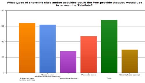
A survey conducted as a part of the planning process asked the public to identify the kind of public access opportunities they would like to see in the Port. Trails topped the list, with places to view maritime activity and places to view wildlife/birdwatch close behind. Places to picnic and boat launch also made the list.
A Port Commission study session is scheduled for tomorrow to discuss the plan for public access to the shoreline. So, what do you think of the plan so far? Do the areas on the map seem sufficient?
Filed under: Waterfront, City Projects, Port of Tacoma, Shoreline Master Program