Remember the Bayside Trails?
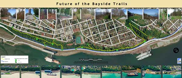
Larger Version (10mb PDF)
The May 31 City Manager’s report to Council (pdf) includes an interesting update on a topic we haven’t thought about in a while: the Schuster Slope natural area.
At the May 8 City Council meeting, the topic of the Stadium Way project set to kick off any day now raised the question of the slope just below that project. The 20-acre area is the site of the Bayside Trails System, opened in 1975. The trail begins below Stadium Way, and continues around the bend of Ruston Way, up into Garfield Gulch The Community and Economic Development Department (which is in charge of overseeing the Schuster Slope open space) provided a fairly lengthy response.
The short answer? Nothing is planned for the short-term other than maintenance.
The somewhat longer answer? There’s a caveat to that: although the Bayside Trails System was closed down in 2000 due to maintenance and monitoring challenges, the original 1975 federal grant contains a requirement for public access of some sort…
The even longer answer? The City-owned asset faces a lot of challenges: slope stability, vegetation management, homeless encampments, and public access, to name a few. There is currently a short-term management strategy, but no robust or holistic comprehensive plan to address the future of the space. In 2011 the CEDD initiated a preliminary public outreach process, and there is some forward movement, if scattered, on a number of fronts. A passage in the report calls attention to what seems like a key public access requirement.
There was no clear majority view regarding how to provide public access to and through the Schuster Slope itself. However, per the 1975 federal grant funding agreement, public access must be provided in some manner. This highlights the need for a planning effort. Such an effort could move forward subsequent to the conclusion of planning for the Schuster Parkway Multi-use Trail, and the potential transfer of management of the site from CEDD to Public Works …
The trail has a lot of overlap with other spaces, which provide a convenient way to break the longer trail up into smaller sections for consideration. One: It connects to Metro Parks-owned property in Garfield Gulch. Two: Although it is not directly impacted by the Stadium Way upgrades, proximity and increased visibility due to that project mean that the two are not completely separable. Three: the downhill portion of the middle section has a clear connection to plans for a Schuster Parkway multi-use trail.
As with so many other projects right now, limited staff and budget resources pose a major barrier to progress. There is discussion around transferring management of the space from CEDD to Public Works’ Environmental Services Division, which might help with that, but that hasn’t been settled yet. Another important consideration is that although the City is required to maintain facilities and ensure public access, that doesn’t have to look like it did originally.
So, while budget gaps and related questions are certainly the serious matter of the day, we’re also firm believers that you have to dream too; otherwise what’s the point? So, Tacoma, once you’ve completed your budget scorecard and put your public budget meeting date on the calendar, while we have a minute, what are your dreams for the Schuster Slope?
Perhaps there’s a way to connect the Bayside Trails to the waterfront walk – take a look at David Boe’s ideas on the Walk the Waterfront component of the Shoreline Master Program for an idea or two.
View the Bayside Trails project page at www.CityofTacoma.org/Planning.
Filed under: Transportation, Walkable Tacoma, Biking, Waterfront, City Projects, Ruston Way, Shoreline Master Program
4 comments
M Morf June 7, 2012
I used to love those trails. Wonderful lunch time walks for those who work or live downtown. Great views – especially of sunrises and the 4th of July fireworks.
Could be a world class trail/view system.
J JOHNESHERMAN June 7, 2012
Is there a mistake in this article reporting—-for example, presented is “Public Works’ Environmental Services Division” which sounds like a Municipal Public Utilities Ratepayers defined services; therefore, the correct City of Tacoma General Government agency for trails construction, maintenance, and funding should be City of Tacoma Public Works Streets and Grounds funded only from City of Tacoma ‘Taxpayers’ not defined services ‘Ratepayers’!
M Maria June 8, 2012
A safe and well-designed trail would be really great.
If this is connected to the Prairie Line Trail and the rest of the waterway (down to the MOG and up to Point Ruston and Point Defiance)…that would be an amazing asset to the city. For tourists, bike commuters, people wanting to walk and stay fit.
I’m always amazed when up in Seattle how busy the Burke-Gillman trail system is. Never been a day up there where I haven’t seen tons of activity on it. Well-planned walking and biking trails are a real community booster.
C Carla Gramlich June 8, 2012
Stadium Way is an entry point to our fair city. Having a wooded area surrounded by fences is poor way to show off our city. I understand there has been problems with the trails but I believe if we went in clean up the trails and start to get people to use that area some of those problems will go away. OPEN this space for the good folks.