Boe - Imagining a Waterfront Walk
Last week City Councilmember David Boe presented a few sketches of a possible waterfront walk solution to the City Council. We asked him to elaborate. Here’s what he had to say:
Given the amount of public testimony received on Walk the Waterfront – from both sides of the argument – it seemed that the Council would benefit from looking at the reality of walking the waterfront assuming that the BNSF train tracks are to remain, and remain in an active state.
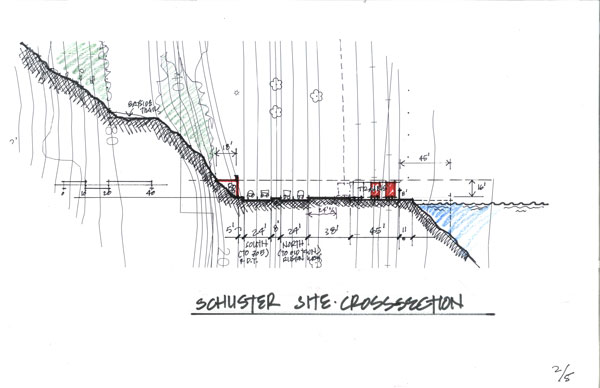
Once you accept that the trains are there and operational, then it becomes clear that any sort of walkway along the waterfront will need to be protected from the trains by at least a 6-foot fence (as the two tracks next to the water are for trains that are staging for the grain elevator, and given the fatalities at Titlow Beach, this is a needed requirement to protect the public).
Once you take this into consideration, you realize that for most of the waterfront from the grain elevator to the Saltwater Marsh has very little width for a walkway (from about 6 feet to about 12 feet), AND this walkway is completely screened from the public right-of-way along Schuster Parkway. This ‘isolation’ of any walkway from the public right-of-way will result in an unsafe condition for public access, since it is located behind a row of trains, fenced off from escape across the tracks, and a potential quarter mile from any connection TO a public right-of-way. My experience in CPTED (Crime Prevention Through Environmental Design) as an architect here and abroad tells me that unless a public access way is visible from the public right-of-way AND is reasonably accessed by a police cruiser, it will be unsafe.
For example, the Wright Park improvements of opening up the center of the park with removal of trees and clearing the undergrowth allow for visibility from the edges of the park through to the center, and with lighting this has created a much safer environment.
If it is unsafe, it will not be used. If it is not used, what is the point (consider the history of the Bayside Trail or the Broadway Plaza pedestrian mall as points of reference).
Additionally, our requirement for a 15 foot-wide walkway is not achievable without building a pier or similar structure along the waterfront (an even greater cost is possible with all of the environmental regulations).
But, a connection along here is vital for completing the Walk the Waterfront. Soooo – what about improving the upland bank to include an elevated walkway along the bluff? Such a walkway, about 16 feet high would allow users to see over the trains, and could be tied into the parts of the existing walkway that are back away from the roadway. This would allow visibility to Schuster and accessibility for police vehicles, while also allowing for incorporation of a drainage system for the perched water that drains off the hill, and could provide bank stabilization, as well as a possible utility corridor connection for TPU, and the added benefit of safety for the roadway from a sloughing hillside. This walkway could be constructed in phases (working from the center of the connection both ways), and give incremental improvement to the trail. It could also incorporate upland connections to the existing Bayside Trail for the Intrepid.
If this sounds like a reasonable plan, then the big $$ item is the connection at each end. Initially these could be constructed ‘at-grade’ with better signage, median barriers, and lighted crosswalks. Eventually a pedestrian over-pass could be added.
Connections
4th Street: This connection could use the existing ramp up to the highest point of the bridge, and then separate to a level crossing to the bankside promenade (it is interesting how Schuster Parkway dips down after 4th so the connection could be made right across).
Hyde Park: The reality of the Chinese Reconciliation Park is that it is NOT a linear park – it is actually proposed to be an enclosed park/garden. To the south of this is the Saltwater Marsh, which is not supposed to have access through it. Together, these are a linear stopper for Ruston Way. Any continuation of the trail therefore needs to start at Jack Hyde Park. What I conceptually show is a similar pedestrian bridge that could be built-off the ramp, then down the median until it gets to the bankside. That would allow for connection into the new elevated trail (actually this is where one of the ‘recesses’ of the sidewalk currently exists). This connection would be much tougher than 4th Street end, and would probably be the last piece of the puzzle. What happens with Sperry Ocean Dock may ultimately determine if it can come to fruition.
My initial thought on funding is that public access funds in the fee in-lieu program might possibly be used (and for me this would be a much better use of public access rather than creating small ‘pocket parks’ in the Port that take up valuable port land AND are seldom used by the public).
David
Here you can see the suggested walkway on the left, raised above traffic and trains.
The 4th Street transition.
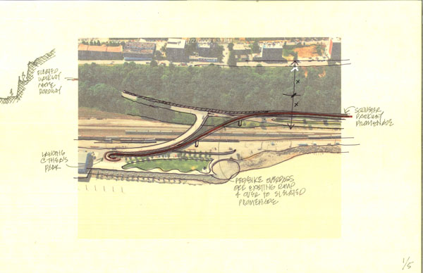
The Sperry Dock section.
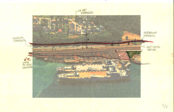
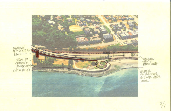
Salt water marsh, Chinese Reconciliation Park, and a potential solution for crossing over Schuster.
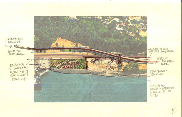
The Jack Hyde Park transition to Ruston Way.
Filed under: Imagine-Tacoma, shoreline-master-program
8 comments
R RR Anderson October 27, 2011
what about a tunnel ?
T tacoma1 October 27, 2011
Two words can fix this problem.
Street Diet.
Now that I fixed this problem, where will all the cars go? Half will stay because half actually live or shop in Old Town and the North End, but they will travel at safer speeds. The other half will stay on 16 on their way to Gig Harbor and stop cutting through our neighborhoods at unsafe speeds.
J jesse October 27, 2011
I would bend the railroad tracks at puyallup avenue and put them under pacific avenue at about 21st and 509. Then they would pop out at the north end of downtown thus putting the railroad tracks against the hillside ans Schuster parkway on the water all the way from puyallup ave downtown to ruston… and eliminating the railroad tracks along dock street.
J Jesse October 27, 2011
Then you could tear out 705 north of 21st/509 and connect that intersection to surface streets you create on the land freed up by all of this. Sell the new city blocks to pay for the move of the train to under Pacific Ave.
This would solve a lot of Tacoma’s waterfront access problems downtown and on Schuster. It’s create city blocks in a place where building a tall building is possible because you can dig there.
T tacoma1 October 28, 2011
Regarding David Boe’s drawing on the 4th street transition, it actually looks like a workable plan. My only comment is that there should be bicycle and pedestrian improvements directly towards Pacific Ave too. If a bike or pedestrian commuter is heading downtown they’ll go straight ahead, not down to Dock Street.
A AreteTacoma October 28, 2011
I really like this plan, because it is realistic and workable over time as funding becomes available. It doesn’t rely on tens of millions of dollars worth of industrial investments just getting up and leaving. I agree with tacoma1 @#6. Though it is not really a part of the “waterfront,” a connection to downtown is a must and should be included with any plan to complete the waterfront walk. The retaining wall would not need to be touched at the exit to Pacific Ave. There is extra room under the Stadium Way off ramp and the right turn lane really isn’t needed in front of Old City Hall. A road diet would be perfect there. Use that right lane to create a separated bikeway and pedestrian path to Pacific Avenue that would connect to the new Schuster hill side walkway.
A AreteTacoma October 28, 2011
I just looked at Street View and I may have been a bit mistaken on the location on that retaining wall. That would probably cost over $1million to move back and enlarge, but it’s still doable. Some type of lidded cut and cover structure could do it too, might cost even more though.
T talus November 1, 2011
I’m with Tacoma1. A road diet could be a great way to get more room along that stretch. How about reversible lanes, a la Rock Creek Parkway in Washington, DC? Two lanes heading out in the a.m., two lanes heading back north in the evening, and a lane freed up for bikes and peds?