June 11, 2013 ·

Should the Prairie Line Trail Include Parking?

​Should the Prairie Line Trail -  a space intended to be used as bike and pedestrian corridor and open space - also accomodate vehicles?  

That’s the question The News Tribune’s Peter Callaghan asks in an article today about plans for the City-owned portion of the trail that follows the old railroad line across downtown Tacoma.  

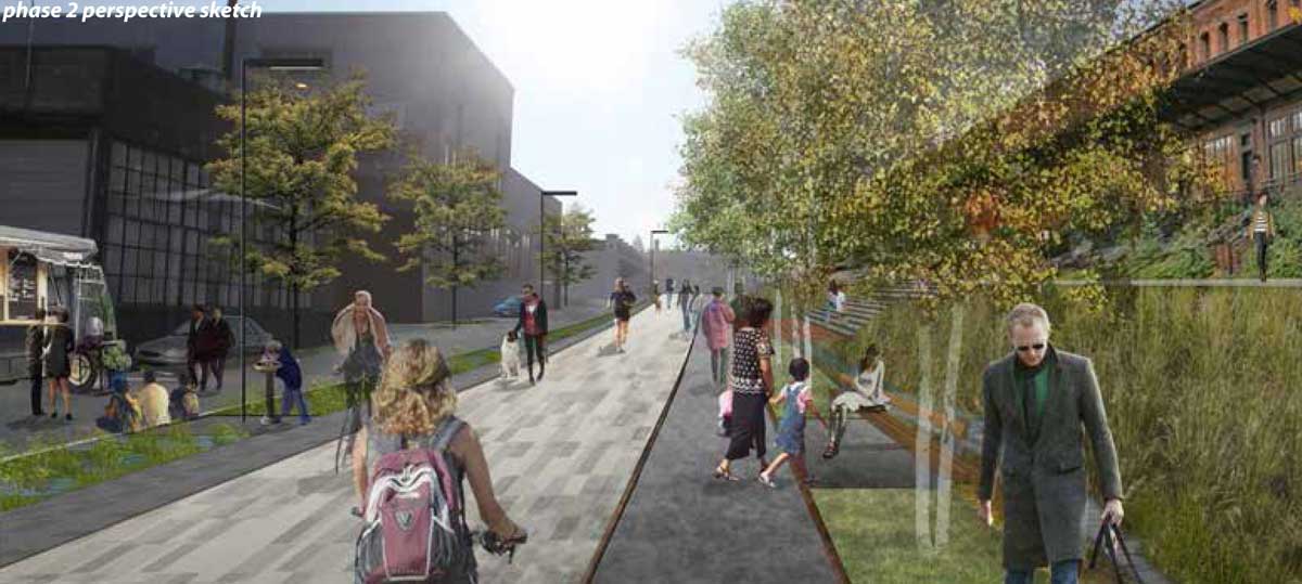
The plans show much or all of the length of the trail (depending on build-out) making accommodations for parking and vehicle access.  This includes parking spaces with accompanying buffers of crushed rock, and what the plans euphemistically call “drive aisles.” The image above, from the latest set of plans, shows hazy parked vehicles in the background (and is that a food truck?) that don’t seem to take up too much of of the width, but it is an artist’s rendering, not a photograph.

The vehicle access was included to allow the few businesses along the downhill side of the trail to maintain parking access to their buildings. Callaghan argues that the property was acquired by the City for open space and the trail - in other words, not for motor vehicle access. His preference would be for as little access for cars as possible, and that no funds raised for the project be spent on paving for streets or parking along the trail. 

The trail is already quite narrow - 20 to 80 feet for most of its length - and the City hasn’t acquired the full right-of-way that would allow space for the planned parking/driving aisles. Parking is always a big issue in downtowns, and the area around UWT is certainly no exception to that rule.  That said, the narrowness of the Prairie Line Trail footprint makes for awfully tight quarters ... What’s your preference?

Filed under: Downtown Tacoma, Transportation, Walkable Tacoma, Biking, Neighborhoods, City Projects, Roads, Prairie Line Trail, Parking

7 comments

  • Xeno June 11, 2013

    Why build anymore roads when you can't keep them from being pothole ridden? The businesses should be using their intended ingress/egress for parking not a historical trail. Hilarious that the city would promote gravel aprons as a temporary measure as well when they let no private developer ever do that.
  • James June 11, 2013

    There's a pretty long history of the failure of pedestrian-only streets in U.S. cities, in terms of creating vibrant urban corridors. Streets that favor pedestrians yet still allow for some local vehicle access are generally safer (more eyes on the street at all hours), have more users, and are more likely to encourage retail in adjacent storefronts. I think that the current design provides for a successful balance of park-like pedestrian space and vehicular access where necessary. At the same time, the design retains the existing historical pattern of the tracks/trail. In opposition to Peter Callaghan's opinion that no resources be allocated for anything that provides access for a car, I would encourage the designers to provide infrastructure that makes the integration of pedestrians, bicycles, and cars as safe, clearly delineated, and durable as possible. I'd hate to see a pedestrian park that lacks vitality and therefore cannot support adjacent storefront retail. At the same time, I'd hate to see a hybrid of pedestrian park and local vehicular access, where the design and construction of vehicular access is given little to no consideration or investment. The Prairie Line Trail is an urban design project and, as such, should consider the full width of the corridor. The successful balancing of disparate uses and the possibility of future growth and storefront activities in adjacent properties are critical to the projects success.
  • Jesse June 11, 2013

    If plans include food trucks or any service vehicles, than maybe the trail should have a parking space or two where the streets are. I'd like to see restaurants with outdoor seating along the line and perhaps outdoor seating laws in Tacoma, and along its sidewalks and streets, need to be changed to include the realistic ability for businesses to use sidewalks for their food service and retail wares..
  • Dan June 11, 2013

    This isn't a street. It's a multi-use trail and a linear park. We don't let people drive around the trails of Wright Park. We don't create parking areas on top of the Esplanade. It is ridiculous that this is being considered. One of the primary purposes of having open space in downtown areas is to get away from the unpleasantness that is interactions with automobiles and traffic. These businesses can be accessed from Holgate St., or Jefferson Ave. If you look at Google Streetview you can see that the corridor is used mainly for free parking. Are we really going to sell out our vision to provide more free parking for businesses that don't even depend on customers coming and going? As for building parking for foodcarts...Shouldn't we first have a successful food cart downtown before we start redesigning our city for them. There area a few places food carts might work, but this isn't one of them. A lot of people need to work within walking distance. I'd say the plaza in front of the Wells Fargo building, the parking lot next to The Big Whiskey, or maybe even Fireman's Park once State Farm moves in.
    • James June 12, 2013

      I totally hear where you're coming from Dan, but the trail is bisected 3 times before it even reaches Pacific. And the scale of the park is 80' wide, a traditional street R.O.W. width. What the plan shows is providing for angle parking (15' street width max) and an 8' drive isle for access. 8' is so narrow, I don't even know how this works, but that's what they're showing. And I wouldn't be surprised if the access is being required by the fire department. One of the project goals is: "Development - Catalyze economic and neighborhood development by creating a signature public space that connects downtown districts, maintains access for adjacent properties, attracts private economic development, and harmoniously integrates with and enhances its surroundings." So, providing access has been a part of the vision of the park and furthering this goal is not "selling out." Due to the slope of downtown, the frontages of buildings between Holgate/Jefferson and the Prarie Line Trail are on different floors. In order to activate the Prarie Line Trail with these buildings' storefronts (think retail/restaurants), access to the storefronts is critical. This isn't strip mall style parking access. It's looks to be the bare minimum to provide for deliveries, events, and accessibility (ADA). My point is that rather than ignoring this component, since it doesn't fit our traditional definition of 'park', the project should embrace it as part of the design problem. There's plenty of good European examples (woonerfs come to mind), as to how the access way could be integrated with the design of the park.
    • Rollie June 12, 2013

      Several of the buildings between 23rd and 25th only have access to their upper floors from trail level. At least one was built by the City of Tacoma around the turn of the century (1900) and have been used this way ever since. Not allowing cars and delivery trucks in this section would render the upper floors useless. This is why the community has brought the access issue to the City.
  • James June 12, 2013

    Regarding the Prairie Line Trail, bike infrastructure, and the recent guerrilla safety improvements, the story of Indianapolis' efforts are pretty inspirational: http://vimeo.com/68037407#