What's In The Cards For The Schuster Parkway Corridor?
The Schuster Parkway corridor is an area with a lot of overlapping and intersecting projects in and around it. The Stadium Way project and associated upgrades to the slope are underway. After a little drama around the bid, the Pacific Avenue Streetscape project is set to begin next month. In the future there will be plans for bringing back the Bayside Trails in some incarnation, and upgrades to Ruston Way. And then there are the issues that come naturally from doing work in an area with shorelines, wetlands, and steep slopes to consider.
We visited the Schuster Corridor last fall when Tacoma’s Shoreline Master Program was being fought over discussed by City Council and various stakeholder groups. The SMP ultimately passed, and since then preliminary planning has been continuing on options for the Schuster Parkway corridor. A report from the city manager last month lays out the progress so far.
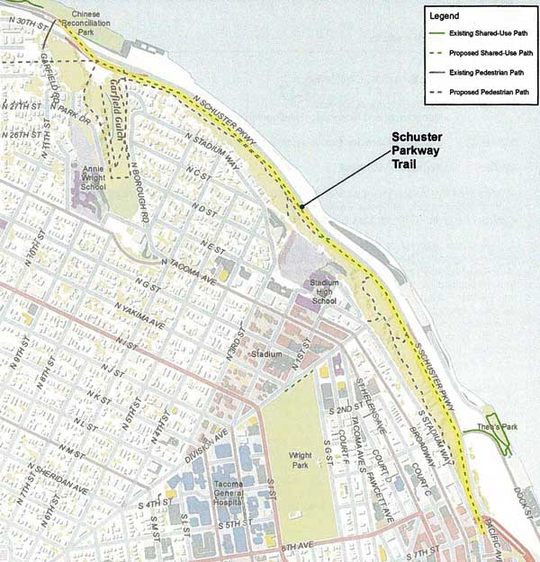
The City Council allocated $60,000 in gas tax revenue for a feasibility and design study of public access options back in 2008. The project was added to the six year Transportation Improvement Plan, and a preliminary analysis of options for the trail was done as a part of the SMP. That analysis identified several possibilities, including an overwater or waterside trail, a reconfiguration of Schuster Parkway and the existing sidewalk, and the Bayside Trail.
Those options will require further study, with attention to connections with Pacific Avenue and Stadium Way upgrades to the south, and with Ruston Way streetscape plans to the north, as well as consideration of stability measures needed for the bayside slope above Schuster Parkway.
Next up is the design process, which will produce a conceptual design for a trail to connect downtown Tacoma to the Ruston Way waterfront. Other considerations in this phase include safe accommodation for pedestrians as well as bicycles, stability of the slope, connectivity with adjacent neighborhoods, and of course, the view of the water. During last fall’s conversation on Tacoma’s SMP we saw some interesting possibilities from Councilmember Boe and a discussion of some of the issues.
With so many issues to consider, this won’t be a quick process, but the City is hoping to arrive at a conceptual design that has significant public support, and that will position the Tacoma to secure future grant funds to enable more detailed engineering and design work, and eventual construction of a shared-use trail that will connect the Foss Waterway Esplanade with Ruston Way. To this end, stakeholder meetings have begun, and will continue in coming weeks and months.
So, what do you hope to see in the plans for connecting the downtown waterfront with Ruston Way?
Filed under: Transportation, Biking, Waterfront, Ruston Way, Roads
6 comments
T the usual jamie October 15, 2012
(cough) road diet (cough)
M Michael October 15, 2012
I second the road diet suggestion. Maybe get rid of one lane and create a reversible lane out in the a.m. in back in the p.m. Would create a lot more room for a good bike/pedestrian trail!
J jsisbest October 15, 2012
Are there any projections of how many additional trips are going to be added once Pt. Ruston is fully built out? As much as I’d love to see serious dedicated two-way bike lanes, Ruston Way and Schuster Parkway are about to become quite a bit more congested. I’m just sayin…
M Michael October 16, 2012
jsisbest, that’s the reason for a reversible lane; there will be heavier use of that road in the future, but you’re not going to have heavy traffic going both ways on Schuster very often, and three lanes instead of four creates a lot more room for people not in cars to use that area. If studies show that two lanes is sufficient, even better. Besides, you can get to Point Ruston via Pearl and other smaller North Tacoma streets as well.
I’d also like to see investment in a solid, safe trail down from Stadium Way and a nicer, less creepy trail up from Old Woman’s/Garfield Gulch. That gulch could be like a mini Ravenna or Puget Sound park, but it needs work.
T tacoma_1 October 16, 2012
Road friggin diet!
Half the cars on Schuster Speedway are headed to Gig Harbor and will go back to Hwy 16 where they belong if given a push. No need to encourage out of towners to speed thru our city.
J jsisbest October 16, 2012
@Michael, if Gig Harbor folks are really using Schuster to avoid HW16, than people aren’t going to take HW16 to take Pearl to Ruston. The reversible lane is a great idea, but I have a feeling that those systems are super expensive since they avoid even putting them on highways. They advocated for reversible lanes on the Narrows Bridge (prior to the new bridge) since that was definitely heavy one way in the AM, and the other way in the PM, but they never got it. I don’t mean to play devils advocate, I just think that we have to be realistic about this. I think that there’s room for bike lanes where the current sidewalk is located, if done right. The bigger issue to me is how to get bike lanes along Ruston Way, since the sidewalk there is pretty packed with walkers and not ideal for flying down on a bike. At the same time, Ruston Way’s two car lanes are too tight for bikers to feel comfortable.
I’m totally with you on improving the gulch trails. I grew up on N. Stadium Way and those trails were our back yard. I’m thinking Carkeek Park in NW Seattle is the best example of what it could look like. I’m of the belief that the safest park or trail is the one most used.